Lykens Valley: History & Genealogy
  • Home
  • About
  • Categories
    • Commerce
    • Communications
    • Education
    • Entertainment
    • Farming
    • Genealogy
    • Government
    • Labor
    • Memories
    • Military
    • Mining
    • Organizations
    • Religion
    • Resources
    • Sports
    • Transportation
  • Civil War Blog
  • PA Historian
  • Contact

Tremont – Big Rock, 1910

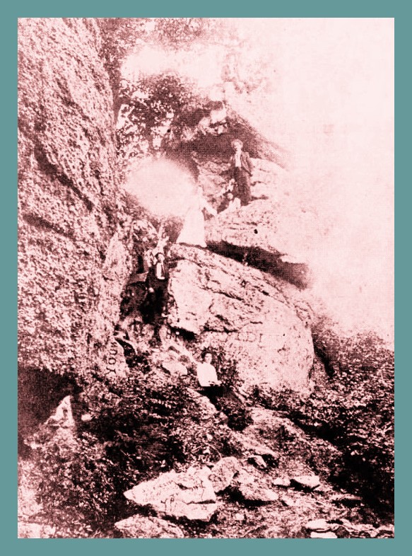
A photograph taken sometime around 1910 of a favorite place for young people called “Big Rock.” This was supposedly located somewhere around Tremont, Schuylkill County, Pennsylvania. When this photo was published in the “Down Memory Lane” feature of the Pine Grove Press Herald, October 7, 1971, the editor had no idea where the rock was located or the names of anyone pictured.

_______________________________________________

From Newspapers.com.

Corrections and additional information should be added as comments to this post.

Share this:

  • Click to share on X (Opens in new window) X
  • Click to share on Facebook (Opens in new window) Facebook

Like this:

Like Loading...

Related

Pine Grove Tremont
August 23, 2022 Norman Gasbarro

Post navigation

Lykens Hometown Heroes – Ronald James Perkins → ← Lykens Woman Dies Following Abortion, 1933

2 thoughts on “Tremont – Big Rock, 1910”

  1. James says:
    August 23, 2022 at 1:59 pm

    From the picture in the paper and knowing the land I’d suggest that this was what is now known as the newtown falls?

  2. Ted Witmer says:
    August 23, 2022 at 10:35 pm

    8/23/22

    Having ridden off road motorcycles from 1970 to present, we spent a lot of time riding that area; Newtown, Blackwood, Tower City, Joliett, Good Springs, and Lincoln. As I recall, there were a set of waterfalls not far from Newtown along Rt. 25 on the right hand side.
    They aren’t there anymore, though. I believe a county or a municipal waste company has a few buildings there and have totally bulldozed a lot of the forest land, including the falls. I did some exploring there last year. Landscape has been rearranged, sadly.

    However, when I first saw the picture, it also looked like the outcropping of rocks along 81 northbound, shortly after the Ravine exit. There is a billboard close to where the outcropping is. Can’t miss it. There were trails up above it that we would take to the old Maxine’s Diner, where the Burger King and gas station are presently located.

Comments are closed.

Email notification of new posts

Places

Ashland Bear Gap Berrysburg Dalmatia Elizabethville Erdman Fisherville Gordon Gratz Halifax Halifax Township Hegins Hegins Township Herndon Hubley Township Jackson Township Killinger Klingerstown Lenkerville Loyalton Lykens Lykens Township Matamoras Mifflin Township Millersburg Muir Orwin Pillow Pine Grove Porter Township Reinerton Sacramento Shamokin Specktown Spring Glen Tower City Tremont Upper Paxton Township Valley View Washington Township Wayne Township Wiconisco Wiconisco Township Williamstown Williams Township

Categories

  • Commerce
  • Communications
  • Education
  • Entertainment
  • Farming
  • Genealogy
  • Government
  • Labor
  • Memories
  • Military
  • Mining
  • Organizations
  • Religion
  • Resources
  • Sports
  • Transportation
  • Unidentified

Categories

  • Commerce
  • Communications
  • Education
  • Entertainment
  • Farming
  • Genealogy
  • Government
  • Labor
  • Memories
  • Military
  • Mining
  • Organizations
  • Religion
  • Resources
  • Sports
  • Transportation
  • Unidentified

RSS Feeds

  • RSS - Posts
  • RSS - Comments

Copyright 2016-2024, Norman Gasbarro, Philadelphia, PA

Site Created by Brian Tomlin

Archives

Powered by WordPress | theme Layout Builder
 

Loading Comments...
 

    %d